Alamosa: 2017 was warmest on record

DENVER (CBS4) – It was a warm, wet year for residents of the San Luis Valley. In Alamosa, it was the warmest year on record, a mark that was just set two years ago.

Climate records date back to 1932 in Alamosa.

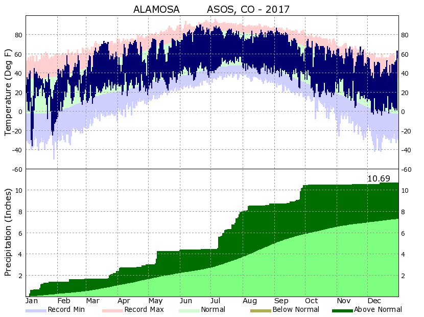
Alamosa’s average temperature in 2017 was 44.7°F which beats the previous warmest year of 2015 by 0.1°F.

2017 was the sixth wettest year on record in Alamosa with over 10 inches of precipitation.

Several other cities and towns around Colorado made it into the top 10 warmest in 2017 including Denver, Colorado Springs and Pueblo.

NATIONAL WEATHER SERVICE
2017 Annual Climate Summary

Weather         Observed  Value    Normal   Value  Depart From Normal
................................................
Temperature (F)
Record
 High              96   07/05/1989
 Low              -50   01/28/1948

Highest            90   06/21
                              06/20
Lowest            -36   01/07

Avg. Maximum     62.5             59.2     3.3
Avg. Minimum     26.9              23.9     3.0

Mean                  44.7              41.6     3.1

Days Max >= 90      2
Days Max <= 32     16
Days Min <= 32    213
Days Min <= 0      25

Precipitation (Inches)
Record
Maximum        11.55   1969
Minimum         3.40     1956

Totals             10.69               7.31      3.38

Daily Avg.         0.03               0.02      0.01
Days >= .01        75
Days >= .10        29
Days >= .50         3
Days >= 1.00        1
Greatest 24 Hr. Total    1.08   07/09 To 07/09

Snowfall (Inches)
Records
Maximum         69.1   1973
Minimum          6.4   1934
24 Hr Total     15.8   12/13/1967 To 12/13/1967

Totals           32.4              27.6     4.8
Since 7/1         1.7              10.3    -8.6

Snowdepth Avg.      1
Days >= Trace      40              22.9    17.1
Days >= 1.0        11               9.3     1.7

Greatest Snow Depth        12   01/06
24 Hr Total     10.0   01/05 To 01/06

Degree Days
Heating Total    7377              8594   -1217
 Since 7/1       2985              3637    -652
Cooling Total      76                52      24
 Since 1/1         76                51      25

Freeze Dates
Record
Earliest     08/09/2009
Latest       07/02/1990

Earliest                        09/08
Latest                          06/08
.................................................

Wind (Mph)
Average Wind Speed              7.4
Resultant Wind Speed/Direction   3/205
Highest Wind Speed/Direction    45/280    Date  06/22
Highest Gust Speed/Direction    59/280    Date  06/30

Sky Cover
Possible Sunshine (Percent)   Mm
Average Sky Cover               0.20
Number Of Days Fair            296
Number Of Days Pc               55
Number Of Days Cloudy        14

Average Rh (Percent)     57

Weather Conditions. Number Of Days With
Thunderstorm             36     Mixed Precip               0
Heavy Rain               11     Rain                      24
Light Rain              103     Freezing Rain              0
Lt Freezing Rain          0     Hail                       1
Heavy Snow                2     Snow                      10
Light Snow               37     Sleet                      0
Fog                      79     Fog W/Vis <= 1/4 Mile     21
Haze                     33

-  Indicates negative numbers.
R  indicates record was set or tied.
MM indicates data is missing.
T  indicates trace amount.

Meteorologist Chris Spears travels weekly in the CBS4 Mobile Weather Lab reporting about Colorado’s weather and climate. Check out his bio, connect with him on Facebook or follow him on Twitter @ChrisCBS4.