
Earthquakes at the Great Sand Dunes


MOSCA — The Sangre de Cristo Fault is a major west-dipping normal fault within the Rio Grande Rift in south-central Colorado and north-central New Mexico. Although the fault is capable of generating Magnitude 7 or greater earthquakes, no earthquakes were felt that originated in the San Luis Valley or Northern Sangre de Cristo Mountains between 1870 and 2003. In December of 2003, earthquakes of M3.5 and M3.1 were recorded 30km southeast of Great Sand Dunes National Park. After these events, no additional events were recorded until March 2014, when an earthquake of M2.7 occurred 10km south of the National Park. Activity died down again until 2018 when four earthquakes were recorded in the last two months of the year.
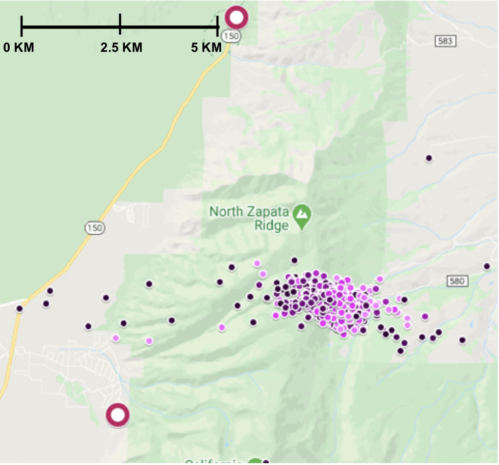
Sporadic activity continued, and four smaller events were recorded in the same location in January of 2019. On February 27, a significant increase in activity occurred, and 27 events were recorded over the next two days, with the vast majority of these events being located roughly 10km south of the National Park. This increased activity has continued sporadically through the present, with 166 events having been recorded by the USGS in the area so far. When the significant increase in seismicity was recorded in late February of 2019, there was only one seismometer (US.SDCO) in the area.
University of Boulder researchers Jackson Bell and Anne Sheehan decided that in order to accurately detect the smaller events in the region they would need to install more seismometers around the region of activity. With the help of the Portable Array Seismic Studies of the Continental Lithosphere Instrument Center (Passcal), on April 13, 2019, they installed an L22 seismometer (Z2. SD01) in the Zapata subdivision, which was as close to the epicenter of previously detected earthquakes as could be reasonably reached due to topography. They installed a second L22 seismometer (Z2.SD03) southeast of the first, on Trinchera Ranch, on May 31. On June 11 they installed the third and final L22 seismometer (Z2.SD02) southwest of the first, on the Alamosa National Wildlife Refuge. The three locations were chosen with the intent to form a triangle of coverage around the activity, using the permanent seismometer, US.SDCO, as the top point of the triangle, and Z2.SD01 as an additional seismometer as close to the activity as possible.
The researchers analyzed roughly 3.5 months of data from June 12 through September 30, 2019 for all four stations and were able to detect and accurately locate over 700 earthquakes, only 44 of which were previously detected by the USGS. The vast majority of the events appear to correspond to a west-dipping normal fault located in the Sangre de Cristo Mountains, located approximately 12km east of the Sangre de Cristo Fault. The repeating nature of these events could signal the involvement of fluids in the seismic mechanisms at hand, as has been seen in other studies, although no known human-induced fluid-related activities have occurred in the immediate vicinity of the fault. After conducting this analysis, the seismometers remained in place until June 2020. Bell and Sheehan are in the process of analyzing the data from September 2019-June 2020. Initial results appear to show an additional 1300 potential earthquakes from this 10-month time period.
Bell and Sheehan wish to express their thanks to Bob Kirkham for his seemingly infinite knowledge on the San Luis Valley area, and his help with the installation of the seismometers. Thanks to Jack Zeman, Aaron Swallow and Trinchera Ranch, and Suzanne Beauchaine and the Alamosa National Wildlife Refuge for their assistance and for allowing the installation of seismometers on their land.